 Forward
 Twitter
 Google+
 LinkedIn


I headed to Glacier National Park in Montana in the morning. The surrounding areas were relaxing and quiet. And the pretty houses on the hill every once a while reminded me of a certain song.
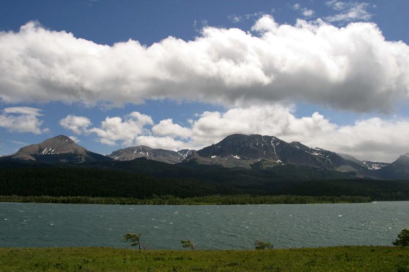
But as I drove north more, the area was not as interesting, and it looked like it would rain at any minute. As I worried, it did rain, but it was not a heavy rain, and once I reached Polson it was not raining anymore. The area with the lake was beautiful and I felt frustration not be able to carry this beauty in my photographs fully.

While enjoying the beauty of Montana, I arrived at West Glacier, the west entrance to Glacier National Park. There was an Alberta Canada tourist information center there. It was rather weird seeing a Canadian tourist information center in the U.S.
Glacier National Park / Waterton- Glacier International Peace Park
Glacier National Park is located in Montana on the U.S.- Canada border with the Canadian provinces of Alberta and British Columbia. Bordering Waterton Lakes National Park in Canada, the 2 parks are also known as the Waterton-Glacier International Peace Park. Together, they were designated as the world's first International Peace Park in 1932 and both parks were designated by the United Nations as Biosphere Reserves in 1976, as well as World Heritage sites in 1995.

Glacier National Park spreads across 1 million acres (4,000 sq. km.) and includes parts of two mountain ranges (sub-ranges of the Rocky Mountains), more than 130 named lakes, over 1,000 different species of plants, and hundreds of animal species. This expansive ecosystem is the centerpiece of the "Crown of the Continent Ecosystem," a region of protected lands covering 16,000 square miles (41,000 sq. km.).
The park is dominated by mountains carved into their present shapes by glaciers during the last ice age, most of which have disappeared over the last 12,000 years. Results from the glacial action can be found throughout the park with U-shaped valleys, glacial cirques, arêtes (thin rock ridges separating two valleys), and large outflow lakes.
The park was established on May 11, 1910, and a number of hotels and chalets were quickly constructed by the Great Northern Railway. These historic buildings are listed as National Historic Landmarks and 350 nearby locations are on the National Register of Historic Places. The Going-to-the-Sun Road was completed in 1932 and later designated a National Historic Civil Engineering Landmark, which provides easier access by vehicles into the main part of the Glacier National Park.
I remembered the first time I visited the Rocky Mountains in Canada. The Rocky Mountains that I saw in Canada were absolutely fantastic! It was totally exciting to see a glacier that close even during the peak summer time.
I heard snow starts to melt from May in Glacier National Park. So about 3-4 months from May seems to be the peak season to visit the park.I took Going-to-the-Sun Road without much expectation. I did not like that the tall trees were blocking the view at first.
While driving up, many cars were parked on the side and I stopped as well. It was a deer and it seemed not afraid of people.

As I drove up further, the weather got bad and windy and it even rained. It was very cold, feeling like minus 5 degrees Celsius with only with summer clothes on. I saw other people were all wearing winter jackets. I felt that Americans are lucky to be able to feel 4 seasons while traveling, even in the summer.
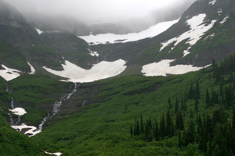
Since the weather was not cooperating, I was not able to take many pictures. But I was completely stunned by the indescribable beauty of nature in Glacier National Park and promised myself to come back here again.
The whole mountain looked like falls. Water falls everywhere and interesting hanging clouds and the beauty of balanced nature made me lose my words.

Going-to-the-Sun Road
Going-to-the-Sun Road is a scenic mountain road through the Rocky Mountains in Glacier National Park. Completed in 1932 and dedicated the following year, it is the only road that traverses the park and it crosses the Continental Divide at Logan Pass. Designated as both a National Historic Landmark and a Historic Civil Engineering Landmark, the road runs 53 miles (85 km.) across the width of the park. Prior to the road’s completion, visitors would need to spend at least 3 to 4 days to see the park.

The 2-lane Going-to-the-Sun Road is very narrow and winding, especially on the west side of Logan Pass. As a result, vehicle over 22 feet (6.7 m.) are prohibited on the highest portions of the roadway. So no large recreational vehicles or trailers that exceed the length restriction are permitted beyond the two larger parking areas located at lower points dozens of miles below Logan Pass (one each on the west and east sides of the parkway).
It remains one of the most difficult roads in North America to plow the snow from during the spring- up to 80 feet (24 m.) of snow can sit on top of Logan Pass, with even more just east of the pass in the “Big Drift,“ the area of deepest snow drifts. Even with modern equipment that can move 4,000 tons of snow per hour, it generally takes about 10 weeks to completely plow the road. The east side of the continental divide has few guardrails because of the heavy snows and late winter avalanches that repeatedly destroy all the protective barriers. The road usually opens in early June (with its latest-ever opening on July 13, 2011) and remains open until around the middle of October.
You have to be really careful driving Going-to-the-Sun Road, but the scenery was simply fantastic!
As I came down, all of sudden the sun showed up and the snow disappeared and the wind felt warmer. The east side of Montana was a large beautiful prairie field unlike the west side.


*This posting was translated. Click here to read the original version.